Part 1: Yosemite National Park
- May 8, 2024
- 30 min read
Updated: May 20, 2024

This is Part 1 of a 3 part series focused on a trio of California's famous U.S. National Parks--Yosemite, Kings Canyon and Sequoia. We will spend four very busy days traveling through Yosemite, then down to Kings Canyon and finishing up in Sequoia. In Part 1, we explore a small piece of what Yosemite National Park has to offer, visiting Yosemite Valley, hiking the Mist Trail, exploring Glacier Point Road, driving Tioga Road out to Tuolumne Meadow, and finishing up in the Wawona area of the park with some Giant Sequoias.
It’s late July and the first day of our California National Parks trip. We got up early to catch an 8am flight from the east coast. Despite being delayed by 30 minutes, we still land close to on time, around 11am, at San Francisco International Airport. By noon, we are on the road, still with quite a bit of driving (about 4 hours) to Yosemite National Park, our destination for the next three nights.
Since we're in California, we are obligated to make a quick stop en route at In-N-Out Burger--it's a must. Their burgers are amazing; the special sauce and freshly toasted bun make them worth a detour any day. While we're in civilization, we also grab some jugs of water, along with a bit of beer and wine.
After a long day of traveling, a little before 5pm, we arrive at the West Entrance to Yosemite (along Route 120), also known as the Big Oak Flats Entrance.* As we drive through the park's ranger-staffed booth, we are offered several ticketing options to choose from, ranging from a one day Yosemite pass to an annual one. Each year, however, we opt for the American the Beautiful Pass, which covers over 2,000 federal recreation sites across the country (including Yosemite and Kings Canyon/Sequoia) for a year from purchase. Our new pass in hand, along with a park information pamphlet and map, we officially begin our journey into Yosemite.
*Important Tip: Per the NPS, they are currently experimenting with a park entrance reservation system. For 2024, a park reservation is now REQUIRED from 5 am to 4 pm on some dates from April 13 through October 27. (April 13–June 30: weekends and holidays only. July 1–August 16: Daily. August 17– October 27: weekends and holidays only.) If you have an in-park camping, lodging, or vacation rental reservation, a Half Dome permit or wilderness permit reservation, or are entering via regional transit or authorized tour groups, you do not need an additional reservation. All of the details about the current reservation system can be found here.
Overview Map of Yosemite National Park

Underlying Map Source: nps.gov/yose (you can find the full-sized park map link here)
Detailed Map of Yosemite National Park

Underlying Map Source: nps.gov/yose (you can find the full-sized park map link here)
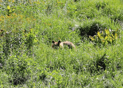
Along our route into the Yosemite Valley, where our lodging is this evening, we see several cars pulled over and stop to see what they’re looking at—we've learned that where a group of cars are stopped, there is typically a wildlife sighting in progress. I've literally just finished telling my husband that I'm hoping to see a black bear while we're here, but I don't think we could possibly get lucky this quickly. Lo and behold, though, it IS a black bear, foraging for food in the meadow below—how fortuitous!!
Interestingly, black bears* come in a variety of shades of brown, and this one is no exception, sporting a light brown coat. There are between 300 and 500 black bears within the boundaries of Yosemite. However, there are no grizzly bears. Despite being depicted on the California state flag, California grizzly bears has been extinct for about 100 years. This particular bear is somewhat masked by the tall vegetation in which it is foraging, but nonetheless, it's an exciting site, and we stay for several minutes to watch it from afar.
*Safety Tip: Remain 50 yards from bears whenever possible, make plenty of noise when hiking so as not to startle one, carry bear spray, and if you do suddenly encounter one, do not run--back away slowly. Bears are often attracted to campsites (and cars) by the smell of food and food-like products; Yosemite has strict rules on food storage within the park which must be carefully followed at all times.


We reach Yosemite Valley Lodge* a little after 5pm. Since we still have some daylight left, we decide to explore the Valley a bit on foot. First, though, we check into our room and drop our bags. Lodge rooms are fairly basic, with rustic two-story buildings with doors opening to the outside making up the majority of the sleeping quarters. Our room is located on the second floor of one of these buildings. It has a bathroom and heat but no television, very limited cell service/wifi, and no air conditioning. The television I can happily do without, but I certainly wouldn't mind some A/C. Our room is fairly stuffy, so we set up the provided fans to circulate the air before heading out to do a quick loop around this part of the valley before dark.
*Lodging Tip: Getting lodging inside of the park can be very difficult--and a bit overpriced for the accommodations you are getting--but it's worth the extra cost and effort for the location alone. Park reservations open up 13 months in advance, and peak season can sell out fast. That being said, I have luck finding an open cancellation for my dates in popular parks if I'm persistent enough in checking back constantly and book each day separately as it becomes available. Book your lodging as soon as you start planning, check back often if your dates are not available, set up an account with your information saved so you can snag an opening quickly if you find one, and have a backup plan (I often book something fully refundable outside the park to ensure I will have somewhere to sleep if all else fails). You can read up on official Yosemite lodging options, check current availability, and make room reservations here. If you are staying in valley lodging in summer, I would also recoomending trying to get a room on the first floor at check-in--heat rises!


Photos: Our Room (Traditional Room, 2 Beds), Yosemite Valley Lodge
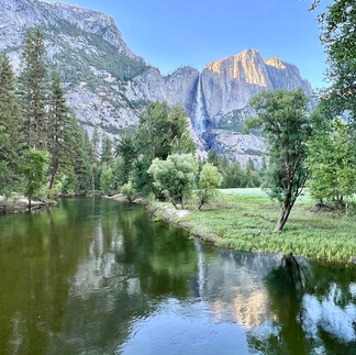
Yosemite Valley is long and skinny, stretching seven miles long, but only one mile wide. The Valley sits at an elevation of about 4,000 ft. So while it may be a valley, it isn't exactly located at sea level. The Merced River flows through the center of Yosemite Valley, bisecting it. On one side of the Merced runs Northside Dr. and the other Southside Dr., running parallel and mostly as a one-way driving route through the valley. Connecting the two sides of the valley are 4 bridges built across the span of the river.
There are several easy walking trails along the valley floor, making exploring the relatively flat landscape a breeze. We want to see if we can fit in a quick stroll along one of these before it gets too late. Sentinel Meadow and Cooks Meadow Loop Hike, a scenic 2.25 mile trail positioned around this area of Yosemite Valley, is the perfect choice.
The Valley is beautiful in the evening, especially with quiet brought on by the departure of the majority of day trippers. The temperature outside is relatively comfortable, with the sun already behind the towering granite walls surrounding us. Sunset isn’t until after 8pm this evening, but on this side of the valley, there’s already no sign of the sun, which has an instant cooling effect.
We take in the view around us, staring up at the immense, sheer rock face of El Capitan. It is probably Yosemite's most recognizable landmark, and no wonder, at 3,600 feet tall, it stands as the world's tallest granite monolith. Photos simply cannot do this impressive sight justice.
We comes across a small beach with people wading into the cool river water* below and debate joining them. However, I'm more interested in exploring our surroundings at the moment--plus, the water is surprisingly chilly when we feel it. The bridge crossing over the river forms a gorgeous vantage point from which to take in the Vally scenery spread out before us, though.
*Safety Tip: Water related accidents are the second most common cause of death in Yosemite National Park. Never enter water when you don’t know the conditions/what’s downstream. Yosemite has many park specific tips on water safety located here.


Photos: Yosemite Falls from the Valley Floor (left & center); Upper/Lower Yosemite Falls from Taft Point (right)
Yosemite Falls forms a striking backdrop, cascading along the sheer cliffs surrounding us and plunging into the valley below. Consisting of an upper falls, middle cascade, and lower falls, it all stands at an impressive 2,425 feet tall (Source: NPS). It is one of the tallest waterfall in North America. Parts of the Upper and Lower Falls can be spotted from various places around the Valley, as well as from the Valley Lodge. Typically, at this time of year, the falls are reduced to a trickle, but these tumbling torrents are all still on full display.


Photos: Yosemite Valley (left) & Yosemite Community Church (right)
We also pass the Yosemite Community Church on our walk. Built in 1879, it is the oldest structure in the park still in regular use. Taking in a service with this backdrop all around you must be a truly one-of-a-kind experience!
After looping around, we head back to our lodging to get ready for some dinner. We had originally planned to eat at The Mountain Room, an upscale restaurant in the Lodge. However, the wait is a bit long, the menu is fairly pricey, and we would rather just have a quick meal and get some sleep tonight. So, instead, we head to Base Camp Eatery, the quick service option at the Lodge.


Photos: Base Camp Eatery Ordering Kiosks (left) & Falafel Salad (right)
Base Camp Eatery serves a variety of cuisine option in a cafeteria-like setting. There is open seating, you order and pay on a kiosk, and they call your number at the various windows when your items are ready. It is essentially a step up from basic/fast food--there is everything from pizza, poke bowls, chicken/fries, and mediterranean cuisine options. We opt for mediterranean food and split a falafel salad (hummus, greens, lemon tahini dressing, tabouleh, pickled onion) and a chicken gyro. We find the food tasty and affordable—perfect for a quick dinner. After dinner, we head back to our room to get everything set for an early start tomorrow, followed by a good night's sleep.
Unfortunately, I wake up at 3am with a pounding headache—I assume it’s just me adjusting to the altitude since the valley sits at about 4,000 feet above sea level, and I never sleep particularly well at high altitudes. However, by 5am, I am feeling very nauseous, and the water I have been slowly sipping to try to increase my hydration comes right back up... not a good start to the day.
Nonetheless, I try to pull it together; we are in the middle of the spectacular Yosemite National Park, and we have so much planned for today! I actually feel a bit better now, so I get ready for the day. Today we have a lot of hiking planned, so not only will I need my energy, but I will need to be able to stay hydrated. This should be interesting.
The plan is to get a very early start on the Mist Trail to Vernal Falls; it’s a difficult hike, and I want to hike to that point and then potentially past it to Nevada Falls located farther above it. It’s a fairly strenuous hike, though, at over 6 miles with quite a bit of elevation gain (up the Mist Trail and down the John Muir Trail), and I’m not currently sure that I’m up for it—but I’m game to try. Luckily, it’s early in the day (about 6am by the time I'm ready), so there’s no heat—I’m actually wearing a long sleeve and still feel a bit chilly. At night, the temperatures in the valley are projected to be around 59 while we're here, but it climbs to above 90 during the day. Dressing in layers is definitely key.
We take the car to the Yosemite Valley Trailhead Parking Lot and are still early enough to snag a space. We can see that there won’t be spots left for long, though.* After getting our hiking sticks and water backpacks settled, we walkthe 0.5 miles down the road to the Happy Isles Bridge and the start of the Mist Trail. I slowly sip some water along the way, hoping my stomach stays settled; I'm really hoping I’m just a bit jet lagged after our very long day yesterday.
*Tip: If for some reason you can't arrive at the parking lot early, you most likely will not be able to get parking. Instead, you can take the Yosemite Valley Shuttle to the hike starting point (Happy Isles, stop 16). If you don't want to have to worry about parking around Yosemite, the Yosemite Valley Shuttle Bus is free, air conditioned, runs two different routes across 20 stops, and departs every few minutes from 7am-10pm. However, for us, a 7am start is too late to be ahead of the crowds, it runs in a one-way loop, and it can get very crowded (i.e. waiting for one you can get on), so we opted not to use it. You can find more information, including the shuttle map here.


We start off on the trail to Vernal Falls, and I soon realize why they rate this hike as difficult—we literally climb straight up and up a steep incline without much of a reprieve. It would be a difficult, calf shredding climb regardless, but I’m also just not feeling my best this morning. Despite my less than stellar energy level, though, I make it the 1.3 miles—very uphill—to Vernal Falls. I even manage to keep the bit of water I’ve take in along the way down. The last section of the hike is on stone steps, and we can feel the mist coming off the falls. It’s been a record snowfall year, and even though it’s nearly August, the Valley falls are still roaring (many summers they turn to much more of a trickle or even begin to dry up by now).


Photos: Hike to Vernal Falls/Vernal Falls
I'm still feeling ok, if not my best. That being said, the thought of hiking essentially the same distance further uphill, up slippery stone steps and more inclines to get to Nevada Falls is just not something I think I can take on right now. My husband agrees that he’s happy to turn around at this point; we got to see Vernal Falls, which was the number one goal of setting out on the hike.

The hike back down is difficult in a different way, but significantly faster than the trek up. I’m a bit disappointed, as I’d hoped to go all the way up to Nevada Falls, but I don’t want to push it, especially with the worry that I could end up getting dehydrated as the day heats up. Dehydration can come on very quickly in 90 degree weather, and risking that right now just wouldn't be smart.
On the way back down, we see a lot more people heading up. Getting onto the trail early is key. We’re ahead of the park shuttle that begins running at 7am, stopping at the entrance to the trailhead, continuously spilling off hikers. An early start makes for a much more peaceful experience!
After the falls, we decide to go in search of some breakfast; I want some hot tea to settle my stomach and something starchy now that I feel well enough to eat something. We try Yosemite Village, stopping in the large Village Store while there, but nothing appears to be open for food here. We conclude that instead, we’ll just head the short distance down the road back to Base Camp Eatery, where we got dinner last night, which opens at 6am each morning.
My husband orders a hot breakfast platter—scrambled eggs, breakfast potatoes, choice of meat (sausage), and a small croissant—he already made coffee in the room this morning. I get a large butter croissant and an English breakfast tea. The croissant is warm and soft and delicious, and it settles my stomach further, along with the tea. I even have a few bites of my husband’s meal. Now that I'm feeling significantly better, we decide to tackle Glacier Point Road and two shorter hikes we want to do along the way.
The entrance to Glacier Point Road is about 15 miles outside of the Valley center. The road is closed in winter and only recently reopened due to an ongoing maintenance project. When open, Glacier Point Road is arguably the highlight of the park. At approximately 16 miles long, it provides amazing viewpoints over the Valley below. The Road dead-ends at Glacier Point*, arguably the park's most famous vista, and you must retrace your steps back to return to the Valley below.
Glacier Point Road is also home to two well known hiking trails (both leaving from the same parking area)—Sentinel Dome and Taft Point. Each hike is a 2.2 mile long (round-trip) out and back trail. They each provide very different perspectives of the Valley, with Sentinel Dome affording more of a 360 degree viewpoint from the top of a dome without all of the climbing (the trail is fairly flat) and Taft Point providing some truly jaw-dropping valley views.
*Note: For planning purposes, it takes about an hour to drive from the Valley floor out to Glacier Point.


Photos: Sentinel Dome Hike
Since Sentinel Dome is supposed to be a bit less difficult, we decide to start with that one and see how well I am feeling. The hike isn't hard, but the trail can be narrow in places. We are mainly just required to navigate around roots and other vegetation, watching our step along the way. We traverse the path fairly quickly and soon arrive at Sentinel Dome.
At Sentinel Dome, I’m slightly unimpressed—the view is pretty, but it’s certainly not jaw-dropping. After a brief pause, we retrace our steps back along the trail. I’ve read mixed reviews over which trail, Sentinel or Taft, provides the better views. Since we cut our earlier hike short, though, when we get back to the trailhead, I suggest we head in the opposite direction to check out Taft Point.


Photos: Taft Point Hike (left); View From Taft Point, Yosemite Falls In The Distance (right)
The hike starts out through a forested area, which is a welcomed break from the sun. It's relatively flat and easy-going. Near the end, we come out above a point jutting over the valley, and walk downhill to it. The view from this end of the trail is gorgeous*. We can see Yosemite Falls and several other famous valley sights spread out below.
*Safety Tip: Pay close attention to your surroundings at Taft Point. Rock fissures are prevalent and a few seem to come out of nowhere—you don’t want to find yourself falling through one--the drops can be as much as 2,000 ft!


Photos: Slack Line Over Yosemite Valley At Taft Point
The craziest thing we see, though, is a woman balancing out on the slack line strung across a chasm over the valley. She’s calmly doing silks poses whole someone photographs her—you couldn’t get me out there for a million dollars. Just watching her gives me anxiety! It’s awesome to get to see something like this, though. It's like a free encore to the panoramic valley view. Taft Point is truly spectacular*.
*Tip: In my opinion, if you plan to do only one of the hikes, Taft Point wins hands down over Sentinel Dome. Taft Point is a little more climbing down/up at the trail's end, but it’s relatively flat until that point, and parts of it are in the shade of trees, which is nice midday. The view from Taft Point is incomparable to Sentinel Dome. If you’re afraid of heights, Sentinel Dome is probably the better option, but there’s no reason you can’t stay well back from the edge at Taft Point—the hike itself doesn’t have any steep drop-offs.


Photos: Vernal Falls and Nevada Falls from Washburn Point (left); Washburn Point View (right)
After we complete the return hike from Taft Point, we drive to Washburn Point and take in the soaring views from there. We get to see both Vernal Falls and Nevada Falls from up here--a much easier way to see the two waterfalls than our earlier hike! I've read that the view from Washburn Point is similar to that of Glacier Point, though not quite as spectacular. If that’s true, I’m excited for Glacier Point because it’s gorgeous here. We only have to drive another 0.7 miles to see for ourselves!
When we arrive at Glacier Point, we luck out with a parking spot. Parking here can be rather tricky in peak season. Fortunately, cars are always coming and going, and we snag a departing one's prime location. Glacier point is only a short walk from the lot.


Photos: At Glacier Point
The only place to get food along this section of the park is at Glacier Point. There is a dual purpose shop/snack bar located near the parking lot. We stop to take in the soaring view from the overlook in front of the snack bar, but we’re hungry, and it’s lunch time. So, we pop into the Glacier Point store/snack bar, finding several varieties of wraps, salads, and pre-made sandwiches available in a refrigerated case. We select a turkey and cheese with a pesto mayo to share. The bread feels surprisingly soft for being in a refrigerator case, so it must have been made fairly recently. We share the sandwich and my husband also gets a strawberry frozen fruit bar from the ice cream case. I find a locally made Christmas tree ornament of the park that will be perfect for my ornament collection in the shop, as we'll.

After finishing our sandwich, we walk the length of the short viewing path that runs along the rim down to the "official" viewpoint. However, the views are good the whole way down, each spot offering viewpoints one more jaw-dropping than the next. Glacier Point sits at an elevation of over 7,200 feet, so we have quite the panorama spread before us.


Photos: Views At Glacier Point
We stroll slowly, taking in Half Dome, El Capitan, and the extensive valley below. We can truly see why Half Dome gets its name from here. Dominating the skyline, and soaring nearly a mile over the valley below, the severed dome may be the valley's most unique feature, but it has a lot of competition! We also spot many of the Valley waterfalls below us; knowing how large and powerful they are, it’s crazy to see how tiny they look, like trickles of water slowing sliding down the granite walls.
*Tip: I recommend visiting Glacier Point and Tunnel View in the afternoon for better views—the sun is above/behind you. If you go earlier, it will be face-on, causing a glare and making photography difficult. I also recommend hitting Tunnel View on your way back as it's significantly easier to turn into and out of the parking lot (which is on your right-hand side on the return trip).

After we're certain that we've taken in the vistas from all angles, we head to the car and retrace our steps back down to the valley below. A little above the valley floor, we stop off at Tunnel View* to take in the same scene from a different perspective. The view from here is very pretty--and well worth the stop--but if I had to pick, I'd say I prefer Glacier Point's soaring perspective.


Photos: Exterior Of The Historic Ahwahnee Hotel
Our excursion out of Yosemite Valley complete, we head back down into it to check out the Ahwahnee Hotel. The Ahwahnee Hotel was completed in 1927 and is designated as a National Historic Landmark. It's supposed to be the epiotome of a National Park lodge, with a log-cabin like exterior and enormous fireplaces. I'm excited to check it out.


Photos: Interior Of The Ahwahnee Hotel
The parking is valet only (and needs validation); so we drop our car at the entrance and head inside. The hotel exterior reminds me a little of Wilderness Lodge at Disney World. Inside, I find the hotel a bit unimpressive for rooms that are $700+ a night, though. It’s pretty, but it’s not as spectacular as I thought it may be, especially as a National Historic Landmark. The huge, old walk-in fireplace I’ve read about is definitely large; however, I expected a bit more character overall. The hotel's renowned dining room, with its picturesque timber ceiling, is currently undergoing renovations; so maybe we are missing the best part. Regardless of "character," though, the various room category photos on the booking site certainly look like a huge step up from the Valley Lodge.


Photos: Ahwahnee Bar--Mojito & Manhattan Cocktails (left); Bar (center); Burrata Appetizer (right)
We stop in the Ahwahnee Bar for an afternoon snack and a cocktail. We share the burrata appetizer--it's tasty but nothing special--and each order a drink off of the cocktail menu. My husband gets a Manhattan, and I select a mojito. The drinks are definitely the stars of the show here. The bartender really takes pride in his drinks, and it shows!


Photos: Ahwahnee Sweet Shop
After we finish up (and get our parking validated), we stop in the Ahwahnee Sweet Shop for some house-made chocolates. There is a huge variety of treats to choose from, but they have milk chocolate coconut haystacks (my weakness), so we have to get a few to.take with us. Once sated, we decide to go back to our hotel and take a swim in the Yosemite Valley Lodge pool.


Photos: Yosemite Valley Lodge Pool (with Yosemite Falls In The Distance)
The pool at Yosemite Valley Lodge (and the one in Curry Village) is open to all park guests from Memorial Day to Labor Day. Access is free to hotel guests and available to non-guests for $5/adult and $3/child (under 12). The Lodge pool is huge and comes complete with views of Upper Yosemite Falls. The water is slightly chilly, but we both jump right into the deep end, happy to cool off after all of the hiking. Since the pool is a walk-in that gets gradually deeper, we swim to the lower end and take up a spot lounging in the shallows, basking in the sun. It’s wonderful—a perfect, refreshing combination of hot and cold.
After our swim, we head back to the room to clean up for dinner. Our building is conveniently located a quick walk across the parking lot. The room, unfortunately, is very warm and stuffy at this time of day, though. Given the current room temperature, we don't linger for long after getting showered and changed.
Once ready, we have a quick pre-dinner hike planned. Hike is probably a bit of an overstatement--we just want to walk to the base of Yosemite Falls, which is 0.25 miles or so from the Lodge. We take the quick stroll down the flat, paved path toward the waterfall. Well before we can see the falls, we can hear them. Once they come into view, we can feel the power of the water thundering into its base, even from a very safe distance away. It’s awe-inspiring--and cooling, with a light mist softly pillowing the air around us.


Photos: Upper & Lower Yosemite Falls (left); Lower Yosemite Falls (center); Black Bear (right)
As we walk back toward the hotel from Yosemite Falls, we encounter a group of people all looking at something and pointing excitedly. We stop to see what they are looking at and find that this time, there is a bear foraging in the forest directly above us, eating something inside a dead log. The bear doesn’t seem to care at all that a bunch of loud people are so interested in it (from a safe distance)—it’s too engrossed in its tasty snack. I wish we had our good camera on us, but unfortunately, it's stowed back in the room. We will have to settle for our cell phone cameras to capture this moment.
Once back at the Lodge, we decide that for dinner tonight, we will once again frequent the quick-service restaurant, Base Camp Eatery. We’re too tired to figure something else out, and the meals there are more than adequate—and affordable. We each end up choosing the falafel bowl again--we're nothing if not consistent! However, I do decide to add a side of French fries to the order—they look so good; I can never resist a good crinkle cut fry.
It's been a very long day; so after dinner, we head back to the room to relax. Along the way, we encounter two fawns taking an evening stroll in front of our building. They aren't bothered at all by the gawking tourists, and continue on their way at a leisurely pace, seemingly enjoying the cooler evening temperatures. Luckily, back at the room, it's cooled off a little since this afternoon, as well, but it's still hotter than I'd like it. That being said, we're both exhausted; so we have no trouble falling asleep, lulled by the gentle hum of the fans.


In the morning, we are up early, packing. Tonight, we’re still staying in Yosemite but farther south in Wawona. Wawona is about 27 miles (a 45-60 minute drive) from the valley floor. It’s a few miles inside of the park’s south entrance, which we’ll be heading out of tomorrow; so, sleeping there tonight will save us some time en route to our next destination. It also happens to be very close to Mariposa Grove--home of some of the park’s best giant sequoia trees, which we plan to explore later on this afternoon.
However, first, we are going to traverse part of Tioga Road, on the park's east side, to explore Tuolumne Meadow. Tuolumne Meadow is about an hour and a half drive from the valley floor, so we have a little bit of a trek ahead of us this morning. It is a subalpine meadow*, encircled by the Sierra Nevada Mountains, with a scenic river (the Tuolumne River) flowing through it. At an elevation of 8.600 feet, it is one of the highest meadows in the Sierra Nevadas (source NPS). Tuolumne is home to a plethora of both flora and fauna--peak wildflower bloom is in July; so we should get to see nature's rainbow on display.
Heading out of Yosemite Valley, we take Big Oak Flats Road toward Tioga Road, passing the Big Oaks Flat Vista Point and the Yosemite Valley Vista Point (both easy stop-offs). Before take off toward the meadow, we stop off at Crane Flats Gas Station, at the intersection of Big Oak Flats Road and Tioga Road, for a quick fill-up. It's the last option for gas in the park between here and the end of the park boundary on Tioga Road. So we don't want to take any chances. We fuel up on some caffeine at the adjacent convenience store.
Tioga Road is a less crowded area of the park, but it is still well traversed, offering a very scenic driving tour for those not afraid of a few twists and turns in some slightly precarious places. We aren't driving it the whole way to the park's east exit (56 miles), as that would add quit a bit of time to our side-trip. However, we are traversing the most popular section of the road--the first 38 miles to Tuolumne Meadow*.
*Tip: The elevation of Tuolumne Meadow impacts the air temperature. The meadow area is typically 15-20 degrees Fahrenheit cooler than that of the valley floor. While this can be a welcomed relief in summer, plan to dress accordingly.


Photos: Tioga Road/View (left) & A Climber As Seen From Tioga Road (right)
Tioga Road just finally opened a week ago, on the 22nd of July—the latest opening in the road's history. I has been worried that it may not open at all this year. The harsh winter eroded some of the road completely, and the park staff have been busy making some major repairs. In a few places, the road is still only open one way, and we can clearly see why, particularly in areas where the other side of the road has tumbled away down the cliff-side. We drive very carefully!


Photos: Olmsted Point (left) and Tenya Lake (right)
Along our route*, we pass several scenic viewpoints, and even stop off to admire the vistas. The most notable spots are Olmsted Point--with views of the back of Half Dome and Clouds Rest--and Tenya Lake. We also pass climbers testing their mettle on the sheer granite facades bordering the road in places. From our vantage point, they look like tiny spiders crawling their way up the immense rock walls.
Once we reach the meadow, we search around a bit for parking and finally get a spot a bit of a way down the main road from Lambert Dome. Tuolumne Meadow stretches about 3 miles from Pothole Dome to Lambert Dome. You can climb both domes for some great views, but Pothome is the less steep of the two. Since the dome view is best at sunset, though, we decide to skip it for this trip.
Instead, we have plans to explore the meadow on foot, utilizing the Soda Springs and Parsons Lodge Trail. The trail is relatively short, about 3/4 of a mile each way (it's an out-and-back hike), over fairly flat terrain. The destination (Soda Springs) isn't all that interesting, but this hike is more about the journey. It gives us an easy route from which to explore the meadow up-close.
*Tip: There are several other popular stops along Tioga Road to consider. Near Crane Flats, you will find access to Tuolumne Grove. With around two dozen giant sequoia trees, the grove is worth a stop if you aren't visiting Sequoia or Kings Canyon. The trail is about a mile each way (plus 0.5 miles to explore). The hike in is pitched downhill, but coming back up can be fairly tiring. More information on the grove and hike can be found here. There are also several other popular hikes that start from Tioga Road to consider, to include the scenic Cathedral Lakes hike. The hike is touted for its beauty, but it takes about 4-6 hours to complete. More information can be found here. In addition, if you want to venture further afield on Tioga Road, beyond Tuolumne Meadow you will find the scenic Tioga Pass.


Fairly quickly into our hike, we encounter a large buck. His antlers are impressive and in another setting would attract the unwanted attention of hunters. Here, though, he is safe in that regard. He must be used to innocuous tourists strolling around because he continues about his business with barely a glance in our direction.


Photos: Deer At Soda Springs (left); Soda Springs (center); Tuolumne River (right)
Fairly quickly, we reach Soda Springs--and encouter more deer. Soda Springs is a small mineral spring set inside of a log enclosure. Other than having a somewhat red hue, there is nothing unique about it. We trek past it relatively quickly, and check out the Parson's Memorial Lodge. Erected in 1915 from stone by the Sierra Club, it is now another of Yosemite's National Historic Landmarks. Again, it's nothing spectacular, but it's as good a point as any to begin to backtrack through the meadow.
On our walk back toward the car, we divert in a few places (only on designated paths) to explore more of the meadow. The weather is cool and crisp here, and we are enjoying the fresh air along with the scenery. We cross a picturesque bridge over the crystal clear Tuolumne RIver. From there, we have an unobstructed view of the peaks of the Sierra Nevada Mountains, still capped with snow, soaring around us. We also encounter more wildlife, to include a doe with her two fawns in tow. Nature is certainly on full display in the meadow today!


Photos: Tuolumne Meadow
Back in the car, our reverse drive toward Yosemite Valley is a bit less harrowing since we are on the "inside" of the road (as opposed to the cliff side). The trip seems to go by faster than our travels out to the meadow, but we also don't stop at all along the way. After passing the turn-off that would take us back to Yosemite Valley, we head toward Wawona, an area 27 miles to the valley's south.
Wawona is the park's historic center and home to its first headquarters. It is where the park began. The area houses the Pioneer Yosemite History Center, home to some of the park's oldest buildings. It is also the site of to the historic Wawona Hotel, a National Historic Landmark dating from 1879.*
*Tip: If you're running low on gas or supplies, there is a general store, post office, ATM and gas station at the corner of Hwy. 41 and Forest Drive (just north of Wawona Hotel). The gas station can even be utilized 24 hrs/day as long as you have a credit card.


Photos: Wawona Hotel Exterior In Evening (left); Hotel Fountain with the USA & California Flags (right)
Since we got such an early start to our day, we arrive at the Wawona Hotel around 12pm. In a stroke of good luck, our room happens to be ready. So, we happily empty our belongings out of the car. We are given a room in one of the outer buildings, on the first floor, in the back. This is also fortunate, as the rooms on the lower floor, facing away from the afternoon sun, are the coolest rooms in the hotel. Not having air conditioning isn't nearly as much of an issue in this room as in our last one. With the window open and the provided fan set into it, we almost feel as if we do have air conditioning.


Photos: Wawona Hotel--Porch Outside The Room (left); Our Queen Room (center), and Bathroom (right)
After settling in, we head over to the main building to check out the lunch options in the Wawona Dining Room. We're both famished! For our meals, we decide to share a grilled chicken caprese sandwich (tomato, fresh mozzarella, and house made pesto) and a Wagyu cheeseburger with a bacon poblano jam. We're given the choice of a side of french fries or a side salad with our meals and decide to get one of each. Oerall, the meal is good, but the bacon poblano jam is amazing--we both rave about it.


Photos: Wawona Hotel Lodging (left & center); Lunch In The Wawona Dining Room (right)
After lunch, we decide to check out the Pioneer Yosemite History Center which is an easy walk from the hotel. Along the way, we stop to check out the Wawona General Store. It is filled with a variety of different items from food to souvenirs. We settle on a sweet treat to share, make our purchase, and then head across the covered bridge leading into the village.


Photos: The Covered Bridge Exterior (left) & Interior (center) and Wawona General Store (right)
The covered bridge is a unique feature to California; there are only a handful in the whole state. It was erected in 1879 by the Washburn Brothers, who owned the Wawona Hotel at the time. They had relocated from Vermont, where this type of bridge is much more prevalent. The brothers are said to have added the topper to an already existing bridge on this spot as a reminder of home.


Photos: Pioneer Yosemite History Center
Along with housing the historic bridge, some of the park's oldest buildings have been relocated here. We wander through the village, reading the interpretive signs touting the park's formative growth and expansion. It's quiet this afternoon, and we nearly have the place to ourselves. Some of the sights we check out include: the Yosemite Transportation Company Office, the Jail/Powder House, and several examples of cabins from various times throughout the park's history. It's literally like visiting a slice of old Yosemite frozen in time.


Photos: Pioneer Yosemite History Center and Wawona Stables
We also make stops at the Wawona Stables* and the Wagon Shed during our explorations. The Stables house several friendly horses and mules that we stop to say hello to quickly. The Wagon Shed has an interesting historic display, along with a driver stationed there to answer any questions we may have; in summer, they even offer stagecoach rides.
*Note: The Wawona Stables offer a variety of mule and horseback riding options. You can find more information about them here. Blacksmith demonstrations and stagecoach (wagon) rides are also typically offered in the History Center area Wednesday-Sunday from 10am-2pm. See the park newspaper for the latest schedule.


Photos: Mariposa Grove of Giant Sequoias; Fallen Monarch Tree (right)
After the history village, we return to the hotel to grab our hiking backpacks and car keys from the room. We are ready to head to our final stop of the day, Mariposa Grove. Mariposa Grove is situated about 6 miles southeast of Wawona, close to the park's south entrance*. So, it's a fairly quick drive to the Mariposa Grove Welcome Plaza from the hotel. From there, we need to park and take the free shuttle** to the Giant Sequoia Grove. We find a space and get in line at the well marked stop to wait for the next available shuttle.
*Tip: It takes about an hour to get to Mariposa Grove if you are traveling from the Yosemite Valley. If you are headed south to Kings Canyon and/or Sequoia National Parks next, sleeping in Wawona instead of backtracking to the valley (and then back again) make logistical sense. We also found the accommodations at Wawona to be a nice step up from the Yosemite Valley Lodge.
**Tip: There are only 300 parking spaces at the Welcome Center. If visiting in high season, try to plan your visit for a non-peak time of day to ensure you will be able to find a spot. The shuttle operates in peak season from 8am-7pm and runs about every 10-15 minutes. It operates less often in shoulder season (and not at all off-season). More information can be found on the park's Mariposa Grove page here.
Detailed Map of Mariopsa Grove

Underlying Map Source: nps.gov/yose (you can find the full-sized map here)
Mariposa Grove is a pretty spectacular place. It is home to over 500 mature Giant Sequoias spread across about 250 acres. Since we are headed to Kings Canyon and Sequoia National Parks next, to see even more of these astounding giants, we aren't going to hike through the entire grove. Today, we plan to stick to the Lower Grove and some of Mariposa's most famous sights. This is ideal since the shuttle lets us off right at the start of a convenient loop trail covering just that.


Photos: Sign At The Shuttle Stop (left); Fallen Monarch Tree (right)
One of the first trees we encounter is the Fallen Monarch. Sequoia roots do not go nearly as deep as one would expect for the tree's immense size, most often burrowing less than 6 feet into the ground. However, they can fan out to incredible spans of over 150 feet to maintain stability (source: NPS). The roots of the Fallen Monarch provide a unique, up-close look at a bit of the Giant Sequoia's impressive root structure.


Photos: The Bachelor & Three Graces (left), A Tree Cross-Section (center); Lower Grove Trail (right)
As we continue along the trail through the Lower Grove, we come upon the Bachelor and Three Graces, aptly named for a single tree situated in close proximity to three very closely-spaced ones. Photographs simply cannot do these trees justice. Standing below their soaring trunks, squinting up at the sky, trying to see where the branches end and the sky begins, is the only way to truly appreciate their immensity.
We continue to pass more impressive giants en route to our next destination--the Grizzly Giant. The Grizzly Giant lives up to its name. It is one of the largest trees in Yosemite, with a base circumference of over 95 feet and a volume of 30,300 cubic feet (source: NPS)! It is also one of the more ancient Sequoias, with an estimated age of nearly 3,000 years old. This tree's birthday is in B.C.!
Finally, we hike a little farther into the forest to get a look at the famous California Tunnel Tree. Cut through in 1895 so that stagecoaches could pass through the base, the tree has managed to survive the defacing. Today, the coaches are long gone, but it does serve as a fun photo-op.


Photos: Hiking The Lower Grove (left); Grizzly Giant (center); California Tunnel Tree (right)
From the California Tunnel Tree, we continue to follow the Grizzly Giant Loop Trail the rest of the way back to its starting point. After completing the loop, we get in line to catch the shuttle back to our car. From there, we head back to the hotel to clean up and get ready for dinner.
On most Saturdays in summer, the Wawona Hotel holds a BBQ dinner, served outside on the lawn. Today happens to be one of those BBQ dinners, and we can see the staff vigorously setting up for it upon our return. While we're not planning to partake in the event this evening (we have a reservation for the dining room), it does look like a good time.
We also get a look at the hotel's pool. Unlike the one in Yosemite Valley, this one is for hotel guests only. The Wawona Hotel pool is also significantly smaller than the one in Yosemite Valley, but it is more than adequate. While the thought of a dip is tempting after our long day, I'd much prefer a shower, a glass of wine, and some dinner at the moment.


Photos: Wawona Saturday BBQ Setup (left & center) & Wawona Hotel Pool (right)
So, after showers, we head off to the hotel lobby in search of that glass of wine. In the lobby, we encounter the hotel's famed piano player. We sit on the lobby couches to listen for a few minutes but decide to move to the porch where it is a bit cooler. In addition to not having air conditioning in the rooms, the hotel also doesn't have it in the lobby or dining room. The porch, though, has an excellent breeze. It's quite comfortable this evening, and with the lobby windows open, we can still clearly hear the chords of the piano.


Photos: Wawona Hotel Evening Piano Player (left); Hote Lobby (center); Wine On The Porch (right)
At our appointed reservation time, we head inside to the dining room for dinner. This evening, we each choose the same appetizer and meal. For starters, we get the wedge salad with bacon, tomatoes and a blue cheese crumble dressing. For our entrees, we select the salmon with a lemon-herb butter, saffron risotto, and vegetable of the day (which is brocolirabe). We also ask for a side of the bacon poblano jam we had with our burger at lunch. It's an excellent addition to the fish--we both love this stuff!


Photos: Wawona Dining Room--Wedge Salad Appetizer (left) & Salmon Entree (right)
After dinner, we decide to take a short walk around the hotel grounds. The cool evening air is a welcomed relief to the stuffier interior. Soon, though, we begin to yawn. It's been a very long day! So, we head back to our room to get ready for bed. Tomorrow, we are headed to King Canyon and Sequoia National Parks, with another early morning start--on the go as always!
Part 2: Kings Canyon National Park is coming soon!
Credit for Some of the Featured Photos: Kyle Perkins


Comments